Rte.1 closed at Palo Colorado Road
Access from north by twice-daily convoy only
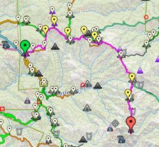
Map
More
USFS closures in effect
Flash flood and debris flow warning for 2020/21 burn areas effective Saturday
More info
Willow Fire Status
Fire 100% contained
Closure order in effect
Willow Post-Fire Closure:
for Marble Peak Trail
Dolan Post-Fire Closures:
for Nacimiento-Fergusson and South Coast Ridge Roads - also trails in J.P. Burns and Limekiln State Parks
Full USFS Forest Closure
Entire Los Padres NF closed
through September 22
Closed State Parks:
Limekiln SP
(except for beach)
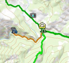
Recent trail closures:
Kirk Creek Trail, until end of July
CLOSURE INFOTrails & Roads
USFS & State Parks
LATEST TRAIL REPORTS24
updates in last 60 days
Latest below, click for all
Jul.4
Kirk Creek Trail
TRAIL NEWS
7
items in last 60 days
filled by index.html js
Jul.25 Soda Spring Tr. Trailwork…
: 1 VWA volunteers worked 2 days
SITE NEWS
2
items in last 60 days
filled by index.html js
Jul.14 Website attacker vulnerabilities hardened => possible problems…
- impossible to fully test, report any problems to
Forum
Wanted:
Gpx track of Lost Valley Trail, Upper Higgins to Pelon Camp
More Info
Trail conditions/closures
are shown on:
Interactive Big Sur Trailmap
Interactive Trail Conditions map
Interactive Route Metrics map
Google Earth overlay
Smartphone map tiles
are optionally shown on:
Printed maps
PDF-format maps
are not shown on:
Garmin-format maps


 Search this website
[Finds words in webpages]
Search this website
[Finds words in webpages]