May 2026: at 81 am no longer able to get to Mount Defiance to assess conditions (last climbed it December 2020),
so decided to describe the path I used to climb Mount Defiance and conditions experienced.
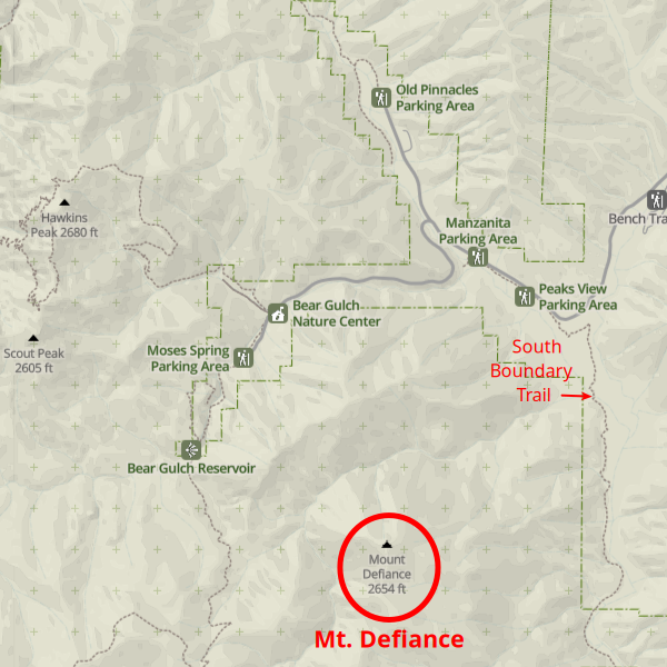
From the Peaks View Parking Area, follow the Bench Trail east to the South Boundary Trail, which you take south to the crossing of Chalone Creek at 0.8 miles from the parking.
I always began the climb from Frog Creek.
Frog Creek itself is open and usually dry, but often a thin barrier of brush must be pushed through to reach it from the South Boundary Trail.
(Alternatively, that can be avoided by leaving the South Boundary Trail to cross Chalone Creek north of the trail's crossing point.).
About 150 ft from the FrogCreek-ChaloneCreek junction, a cairn on the left atop a short steep embankment marks the starting point.
Climb straight up the slope, through open grass and oak trees, for about 600 ft where you look for a game trail heading right with a more contouring ascent.
I once had dead brush piled around a tree to help find the place where I should be looking for the game trail, but likely its no longer there.
(If taking the 'Variation' route, about 0.1 mile after crossing Chalone Creek on the South Boundary Trail look for a metal pig trap to the right,
then start climbing the steep slope to the left of that - eventually you want to find the game trail described below,
which is less distinct and so trickier to find coming from this direction.)
Follow the ascending game trail under oaks for about 0.4 mile until you circle left to reach a grassy saddle.
Make a short descent to the bottom of a gully, looking to continue upward in the same direction heading for a tall pine tree,
then continuing further upslope and circle left to reach 'Brushy Gully' where the ascent lessens.
Back in the day there were enough broken branches that one could wend through Brushy Gully without needing to push through brush,
not in a straight line but by following open areas.
Likely much has grown back since I was last there, so expect this to be the brushiest part of the hike.
After 0.2 miles of Brushy Gully, you circle to the left to leave the gully at the start of 'Rocky Ridge'.
Rocky Ridge is a 0.1 mile long steep ascent (250 vertical feet), made easier by zigzagging horizontally, until the slope abruptly lessens at its top.
At this point a path should be apparent through the surrounding brush.
The route circles around to the left for 0.25 miles before then circling right and heading more directly toward Mount Defiance. Along these sections
look for cairns in the open spaces and gaps in the brush to guide you (breaking a few branches along the way yourself, to help keep the route clear).
About 150 vertical feet below the summit brush largely disappears and I've taken several routes through this open area.
Instead of heading directly for the summit, which has a brush belt below it, it's easiest to head to the right looking for a prominent pine tree
on the ridgeline above the Frog Creek drainage.
Head for that tree, from there move directly upslope to the summit along the ridgeline.
Do not forget to look for the summit register, which hopefully is still there.
Alternate return:
Follow my Hike #2 descent, first following the ridgeline south 0.15 miles to reach a rocky outcrop, which gives a nice view of Frog Creek and beyond,
then leaving ridge to descend 0.2 miles to reach an old encampment, with a small dam for water catchment (the top 250 ft will be brushy, then open)
From there, climb up to meet your entry route.
Cautions:
It's easy (I've done it and have followed others starting to do it) on the descent to think you've reached the top of Rocky Ridge before you actually have,
then start to descend more steeply at the wrong place - with consequent problems! On the ascent, be sure to note what the top of Rocky Ridge, the end of that steep ascent, looks like!
Another tricky descent spot is open area just below summit - note its exit from brush, its route and cairns when ascending. Of course, best way to keep from wandering off route is having GPS with GPX route loaded on hike.
Finding Mount Defiance
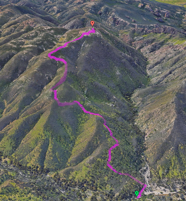
Pinnacles Off-trail Hiking Route
Pinnacles Off-trail Hiking Route
Park Map
3D View
Interactive Map
(note: larger map will appear in a wider window)
(note: text will flow around map in a wider window)

(note: text will flow around map in a wider window)
SUMMARY
Final route up Mount Defiance highlighed in yellow on map, route description and download links for route map &
GPX data & route description found at bottom of page.
South Boundary Trail to Top: 1.8 mi. & 2700 ft.gain
(Peaks View Parking to Base: 0.8 mi.)
South Boundary Trail to Top: 1.8 mi. & 2700 ft.gain
(Peaks View Parking to Base: 0.8 mi.)
History
What does Pinnacles National Park look like from Mount Defiance, its fourth highest peak ? It faces both the "Little Pinnacles", not visible from elsewhere, and the better-known High Peaks Pinnacles. Back in 2009 (when a National Monument) I began wondering, then decided to find out. Esperanza Hernandez, who worked at the park, had heard of some who'd climbed it but their routes were unknown.
Hike #1 (April 11, 2009)
Studying Google Earth, I saw some open routes at upper elevations but all lower sections up from the South Wilderness Trail looked brushy. So on April 11 went out to see for myself. Initially ascending in a narrow gully, getting around/through its brush was difficult and after two hours I'd only gotten 3/4 mile (0.4 mph!). Not very enjoyable and somewhere my binoculars went missing, torn off by brush. So was thinking about aborting, but decided to first check out the ridge above where Google Earth showed less brush. That ten minute climb made all the difference. Now on a "Rocky Ridge" with sparser brush, my speed doubled and an hour later I was on top enjoying the view. For the return, instead of my ascent gully I continued down along a ridge - though less brushy than the ascent, there was enough brush to make it not very enjoyable.
Hike #2 (April 14, 2009)
Esperanza was interested in Mount Defiance, so I invited her along for my next exploration. Hoping for a better ascent, we ascended a different gully to "Rocky Ridge" and descended via a different ridgeline. But both were too brushy to be enjoyable, I'd hoped for something better. Still, we did have a success at "Brushy Gully" as after breaking branches between clear sections that segment was passable. So another piece of the puzzle was in place.
Hike #3 (April 17, 2009)
To experience Mount Defiance from a different aspect, my third trip was a loop hike - approaching Mount Defiance from its steep western side, then descending via the now partially-known route. But this time after "Brushy Gully" I headed north and was gratified to find easy going beneath oak trees to Frog Creek, just off the South Wilderness Trail. So putting together best parts of the previous hikes, an enjoyable route had been found.

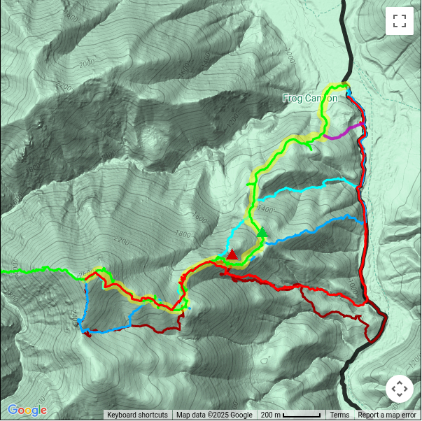
Final Route
Hiking the final route
I led Sierra Club hikes up Mount Defiance in 2010 and 2011, and a Monterey Bay Area Hiking Group hike in 2011. Since then I've just gone solo or with a few friends. I try to get there twice a year, and as of December 2018 have been there 18 times. It's my favorite place in the Pinnacles, giving a grand view of the "High Peaks", the seldom-seen "Little Pinnacles", North and South Chalone Peaks, Frog Creek, a glimpse of Junipero Serra (highest in Monterey County) between the Chalone peaks, and a grand view over the surrounding hills, valleys, and plains.
Later variation
My route start/end requires a short deviation from South Wilderness Trail into Frog Creek, where the entrance point is marked by a stone cairn at creek edge. Getting to Frog Creek can require a push through some brush, so some prefer a more direct route from South Wilderness Trail. The variation marked on the map has a starting point easier to locate, being near a metal pig trap visible from the trail, but its initial climb is much steeper than my traditional route, and to me less enjoyable.
For the view
If you want to go
In my opinion, having hiked on- and off-trail over the entire park, the view from Mt Defiance is one of the best in Pinnacles National Park so well worth your effort. Enough hikers have been using this route to keep it relatively brush-free and mostly apparent (its break-in-the-brush path can be seen in recent satellite views). Some cairns help mark the route where tread disappears, e.g. when traversing some rocky sections (there is no unnatural flagging). But the path can be faint in places or crossed by deer trails, so route-finding experience is needed - and a GPS with the route loaded definitely helps! Note that up to 1100 ft elevation deer trails abound so there are multiple possible routes - above that, you should find a heavily trafficked deer trail and the route becomes more apparent. Metrics: from base to top is 1.8 miles with 2700 ft. total elevation gain.
Veteran's tip

Instead of eating lunch on the large flat summit, find a place slightly downslope on the not-very-flat side looking west, with its into-the-park views of the High Peaks and Little Pinnacles. You've already seen the eastward views on your way up and will again on your way down, but the western views can only be seen while at the top. You've climbed all this way up - so savor the unique view you deserve. And don't forget to sign the summit register, found inside the summit cairn.
Route on
2D Interactive Map
Route on
3D Interactive Map
(reverse view)
On the 3D map, the displayed route can differ from the obvious break-in-the-brush path when viewed at an angle, notably around "Rocky Ridge" - must result from angled display shift since route and path align in a vertical satellite view and the GPX route is accurate.
DOWNLOADS
Printable PDF Map Download: "Final Route" (plus variation)
GPX Data Download: "Final Route" (plus variation)
Route Description PDF Download: "Final Route" (plus variation)
 Jack Glendening