


Since the track is mostly not on regular trails and not familiar to many, the interactive map on right displays my interactive Big Sur Trailmap with the nominal Sea-to-Sky route overlaid as a magenta line. Seeking to similarly inspire others, I've added panorama photos (taken on several hikes) which you can view by clicking the camera icons. This route uses unmaintained usetrails of varying and uncertain condition, at times brushy with poor tread, and a rock scramble section.
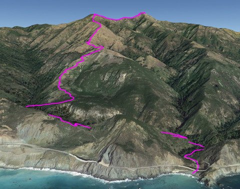
Climbing from Limekiln Beach to Cone Peak, the along-trail grade averages 15% over its 6½ mile (one-way) route. [Detailed route metrics are available at Stone Ridge Sea-to-Sky Route Metrics.] Due to consistent usage, the use trail is currently better defined than many official Ventana wilderness trails - it has relatively little downfall, brush, or vegetation to deal with and the route is apparent, though you must be attentive to extant tread and occasional flagging. But it is STEEP with rough sections and sometimes poor footing, so only for fit and adventurous hikers. The average slope cited above is misleading - more relevantly, from Limekiln Creek to Twin Peak you will ascend 4100 ft in 3.6 miles, an average slope of 22%, and its 0.7 mile "Twitchel Elevator" section averages 31% with shorter sections over 40%.
Hiking poles are definitely helpful ("two legs good, four legs better"), especially on descent when the steepness can be problematic - and especially useful when the grass is dry and slippery (with dry grass, if you can descend without slipping and falling at least once you are doing better than Paul or I).
At top of Alvin Trail, be sure go short distance west to ridge for view of ocean and Route 1 "Rain Rocks" rockshed.
Last water is at Twitchel Flat Creek (drinking glass o map), but that is time consuming to access - so best to fill up at the West Fork crossing of Limekiln Creek (perennial, blue marker on map). Crossing Limekiln Creek can be difficult after heavy rains - crossing is easier a bit upstream from the usual (old roadbed) crossing.
Note that when descending Stone Ridge, you leave its ridgeline after crossing the Stone Ridge Trail - continuing down the ridgeline eventually leads to brush and cliffs, as a few have discovered for themselves.
Of course if there are clouds you aren't going to see much of the vast panorama! Unfortunately cloud forecasts rarely give cloud heights. Summer often givesa low elevation cloud layer at the start of the day, from which you will emergy when higher on the trail, usually clearing to tendrils by the end of the day.
The Crux: at the saddle between Twin Peak and Cone Peak (magenta marker on map), there are several alternatives, all ending on the Cone Peak Trail for on-trail summiting. Being simplest, most hikers continue directly along the ridgeline (magenta line on map) - but its eastern end requires a rock scramble along a narrow ridge with cliffy exposure (hands-on-rocks to go over 10 ft boulders) which has unnerved some. A non-exposed alternative is a short bushwhack to a switchback on Cone Peak Trail (yellow line on map) - but this lacks definite tread to follow, is simpler to take ascending than descending. Robert continued to follow the Twin Peak Usetrail (orange line on map), but in recent years that's seldom used so now rather obscure and not recommended.
At the start, those wishing to make the symbolic finger dip into the ocean at Limekiln State Park usually follow the recently completed Alvin Trail (local name - its state-bureaucrat-prescribed offical name is Pitkins Curve Trail), which winds though redwoods to intersect the Twitchel Flat Usetrail, in lieu of the walk along Route 1 which Robert had to make. Alternatively, or if Limekiln State Park is closed, you can skip that finger dip and instead park and start along Route 1 at the west end of the Twitchel Flat Usetrail (an old roadbed visible from the highway, just north of the rockshed bridge).
2026 update: Route 1 Twitchell Flat Usetrail access
The Route 1 start to the Twitchel Flat Usetrail has been altered by CalTrans work on nearby Paul's Slide,
carving additional work space from what had been the entrance gate with its small parking space.
But reportedly access there still possible, with parking on west side of Route 1.
Descending, due to the steepness of the Stone Ridge Firebreak some prefer to use the Gamboa and Stone Ridge Trails for an alternative descent which avoids that section, making a "lollipop" loop which provides a different experience of the Cone Peak environment (notably views of Sugar Pines and endemic Santa Lucia Fir). Still, descent along the firebreak is more spectacular than the ascent since you continuously view the Big Sur coast below your feet as you hike.
2026 update: Gamboa & Stone Ridge Trail overgrown
This alternative is no longer feasible due to heavy growth, erosion, and lack of trail maintenance.
The hike's main attractions are its spectacular and varying scenic beauty and natural surroundings. Points of interest are remnants of the old Twitchel homestead (stone fireplace and cistern) and the now closed USFS fire lookout atop Cone Peak - and, if you can spot it from afar, an old chimney built atop a coastline ridgelet.
Though the hike is very strenuous, your efforts will be rewarded. The views are outstanding, continuous to all sides since the route is open above 800 ft elevation (with redwoods below that). You will have Cone Peak emerging above and the Big Sur coast below as you hike. In our case, we watched the clouds recede as the day warmed, mostly clearing the beach but with a few tendrils hugging the hills - an iconic Big Sur view. Paul, a long-time Ventana-phile who seemingly has hiked everywhere there, said this hike tops his list of spectacular-view hikes.
An Appeal:
Increased usage has stripped the grass cover on some very steep sections, with erosion then
creating small gulleys with exposed gravel - ugly scars giving slippery footing.
Do your bit to mitigate this by moving side-to-side in such areas, instead of directly
up the slope.
Creating small or large zigzags, instead following the same well-trodden direct route, will help the land to heal - else the path will worsen
and be less enjoyable for all. And zigzagging also makes both climb and descent of steep sections less stressful for you. ![]()
 Jack Glendening