360° Panorama at Cone Peak summit - drag to pan (larger image)
3D View
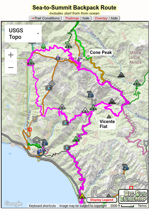
Note: map is interactive, lines & icons clickable for more info - click 'Profile' button to hide/show climb. Full-screen map
Disambiguation: Cone Peak via Backpack or Dayhike ?
This webpage describes a "Sea to Summit"backpack along established trails, overnighting in redwoods at Vicente Flat Camp and then summiting Cone Peak.
I've seen some articles calling this a "Sea to Sky" route,
but do not confuse this route with what locals call the "Sea to Sky" route,
a dayhike along unofficial use trails, ascending much more directly and steeply from the coast -
if looking for the latter, see my Sea-to-Sky webpage.
(updated: )
Cone Peak in Big Sur's Ventana Wilderness
rises to 5154 ft only 3¼ miles from the ocean - an average gradient of over
30% and reportedly the steepest from ocean to a mountain summit along the west coast.
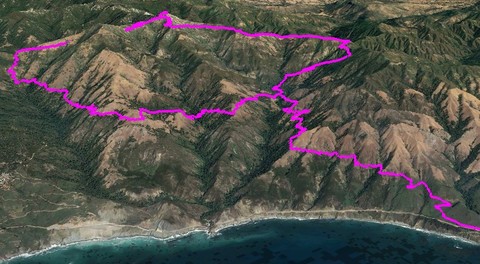
The map on right displays the Sea-to-Summit route in magenta, overlaid on my interactive
Big Surw Trailmap.
This backpack is usually done in 3 days, spending both overnights at Vicente Flat Camp with
a summiting dayhike in between.
The hike's main attractions are its spectacular and varying scenic beauty and natural surroundings.
Though the hike is very strenuous, your efforts will
be rewarded;
Vicente Flat is a wonderful redwood grove, with
perennial water at its upper (northeast) end.
And the views along the entire route are outstanding,
culminating in the 360° view from Cone Peak summit.
To be truly "Sea to Summit", you should first touch your finger in the ocean by descending (without backpack!) to the beach at the end of the Kirk Creek Campground Trail.
This adds about 0.7 mile and 180 ft. elevation gain (round-trip), but makes your backpack an especially unique one.
At one time this page suggested, as an alternative to the simple out-and-back excursion from Vicente Flat Camp to Cone Peak,
taking the scenic 'Cone Peak Loop' to return to Vicente Flat. However, this area was badly burnt by the
Dolan Wildfire in 2020 and almost no post-fire trail maintenance done on the Gamboa and Stone Ridge Trails,
due to difficulty of access (Cone Peak Road no longer giving vehicle access to the trailhead),
so no longer recommended.
A bit of local knowledge can make your hike more
enjoyable. Here are
some thoughts:
• On the way to Vicente Flat, stop to enjoy the views from the "corner" where Kirk Creek Trail turns inland after paralleling the coast -
the simultaneous view of Cone Peak, Hare Creek Canyon, and up-and-down the coast is unmatched in Big Sur.
• Perennial water is available at a side stream crossing the trail just above the upper (northern) end of Vicente Flat Camp.
• If hiking directly from Vicente Flat to Cone Peak via the Vicente Flat Trail, note that water is
not available above Vicente Flat.
• As on most Big Sur trails, you will need to do the "poison oak wiggle" along the trails.
(Note: a dog will bring back PO and ticks to you.)
• Summer is the least desirable season for this hike, due to heat and flies - if you do go then, be sure to bring a bug net.
• Remember these trails are wilderness trails, not park-like trails, and maintained by volunteer trail crews.
So conditions along the route are changable - current trail conditions should be checked on the interactive Trail Conditions Map or using the route-specific links below.
• Parking is along-side Route 1 - officially there is a 72 hour limit but I've not heard of it being enforced there. However, there is enforcement
of people sleeping in vehicles.
Due to the attractiveness of this route, Vicente Flat Campground is often heavily populated on weekends or holidays.
If you wish more privacy, note that the campground area extends 0.2 miles along Hare Creek (campers tend to congregate around the first encountered campsites) and
that nearby Vicente Meadow Usecamp is an attractive alternative (with a view of Cone Peak - but no redwoods or water).
In any case,
do your part to make this an enjoyable experience for everyone by not leaving an unsightly campsite with litter or toilet paper.

 Jack Glendening