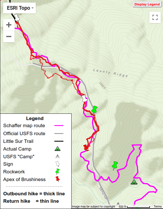
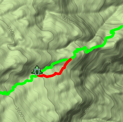
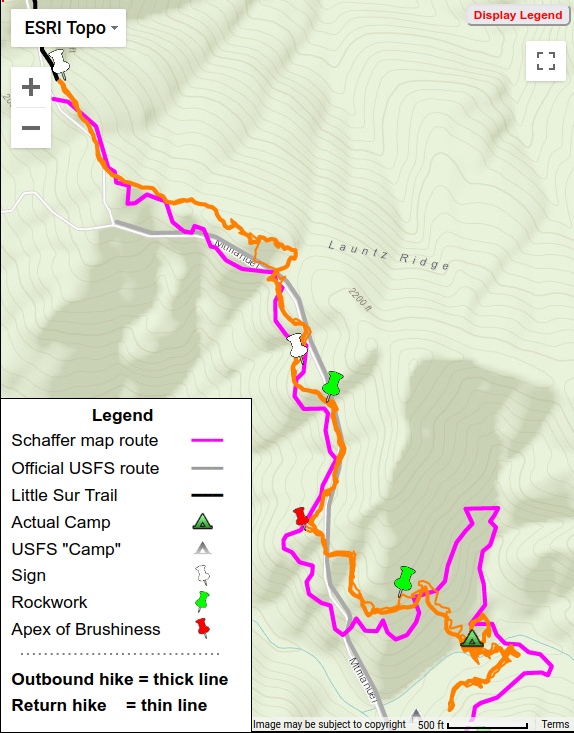
Extravagant flagging, an unhappy couple, Launtz Creek Camp is “found” but have to shortcut trail (with Paul Danielson)
Hike 2 = Orange
Over a year after our first hike, in February of 2012 Paul Danielson and I decided to re-visit the “lost” Mount Manuel Trail – to go beyond the ‘Apex of Brushiness’ which had stopped our last hike and hopefully reach, and so “find”, Launtz Creek Camp. This turned out to be the most interesting hike of my 11 hikes “finding” the Mount Manuel trail.
Little tread, much brush, give up at “Apex of Brushiness”
Find sign and rockwork, Paul follows deer track
(with Paul Danielson)
Hike 1 = Red
February 2011 found myself and Paul Danielson, who had introduced me to the wonders of hiking old trails in the Ventana Wilderness, at Pico Blanco Boy Scout Camp. We’d obtained permission and gate access, but were warned the dirt road was very rough as not worked on since summer. Indeed it was – I needed the 4WD of my Xterra, newly bought for just such places. Being my first time there, the camp’s setting under tall stately redwood trees with nearby creek was very impressive and peaceful.
Many don’t realize that Black Butte is the fifth highest peak in the Ventana (and in Monterey County), only 35 ft lower than South Ventana Cone. In fact, some have not even heard of Black Butte! Yet the views from there are magnificent – the summit is narrow, so gives a 360° panorama from a 4936 ft elevation.
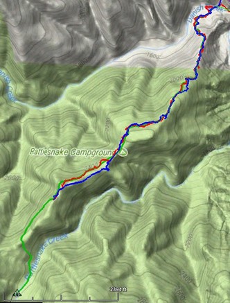
Round trip: 12 miles & 4000 ft gain & 12 hours Hike date: November 25, 2017
Route: Out (red) Return (yellow) Trail (green) (ignore “Rattlesnake Campground” label on map) (click for larger, interactive map) (kmz file)
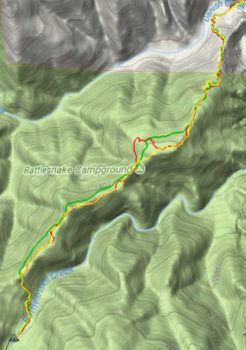
Waking at 3:15AM is not my ideal way of starting a day – but today lack of daylight was not going to keep me from reaching Rattlesnake Camp. Last time I’d had to abort my attempt due to running out of daylight and energy. This time I would start earlier and would avoid the difficulty of trying to follow Rattlesnake Creek Trail – instead, it would be a bushwhack.
Round trip: 11.2 miles & 3760 ft gain & 11 hours Hike date: November 12, 2017
Route: Outbound (red) Return (blue) Trail (green) Note: Rattlesnake Camp NOT where map depicts (click for larger, interactive map)
Sadly, the lower half of Rattlesnake Creek Trail, below Rattlesnake Camp, is now impassable. This venerable trail was one of the oldest in the Ventana wilderness, having appeared on a 1921 quadrangle when few Ventana trails existed.
[Sorry folks, long post and not many photos – was spending all my time deciding where to go.]
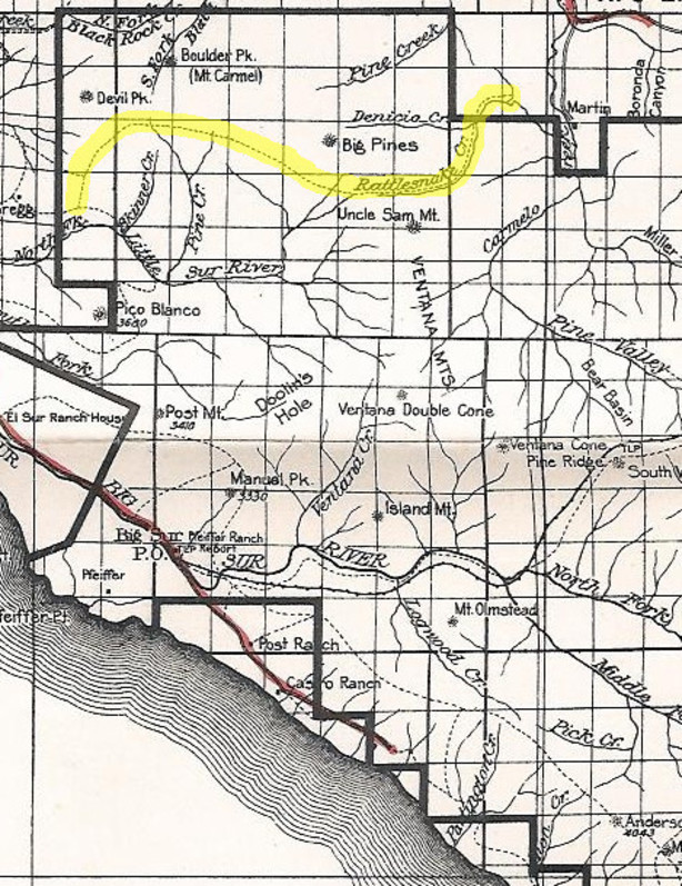
1924 National Forest map (click for full-size image)
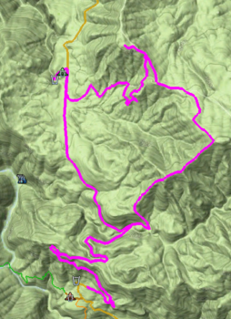
Round trip: 11 miles & 3500 ft elevation gain Hike date: October 6, 2017
Carrizo Trail: 2009=red 2017=green (click to view interactive map)
Hearing that a section of the Carrizo Trail below Carrizo Spring Camp has recently been re-routed (see map), I went out to see what the new section looks like and GPS the new route. I found the trail has been moved out of the paralleling gully, into a drier environment. It should be subject to less overgrowth and easier to maintain – a definite improvement.
While I was out there, I decided to reprise my first Carrizo Trail mapping hike. That 2009 hike was motivated by wanting to find exactly where the trail went, since I’d found different routings on different maps. This hike would be more leisurely, for there has been significant trailwork along the entire trail since them. Back then there was much crawling in brush tunnels and much searching to find the trail – this time I only had to search once and never had to crawl! So I had more opportunity to look around and appreciate the trail and this hike and it was much more enjoyable.
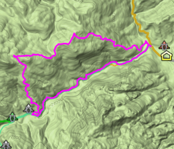
Round trip: 12 miles & 2700 ft elevation gain
Hike date: July 2, 2017
(click for larger, interactive map)
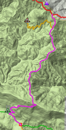
Back in 2010 Paul Danielson and I GPS’d the Santa Lucia Trail from Eagle Creek north to Last Chance Camp, a 19-mile/14-hour marathon highlighted by crawling with a saw under an interlocked ceanothus brush canopy – no actual “trail” but the brush only let us move where the tread had been, other directions being impassable. To get there we’d taken an overgrown firebreak up from Indians-ArroyoSeco Road, which in turn led to an overgrown road. At the time Paul spoke of the other old roads that had once been there, now overgrown, and wanted to return later to explore them. We never did that, but with the Soberanes fire re-opening of the road from Hanging Valley to the ridge above, and the firebreak created along the ridgeline itself, I decided to take the opportunity to see the views from high above Hanging Valley.
Round trip: 5 miles & 1500 ft elevation gain
Hike date: June 29, 2017
(click for larger, interactive map)
The Soberanes fire has greatly disrupted hiking activity in the Ventana Wilderness and caused extensive trail damage from downed trees, slides, etc. To make something positive out of the circumstances, I decided to use a firebreak opened up by the dozers to ascend the ridge north of the scenic “The Rocks” area near the Indians Guard Station, above the Arroyo Seco Trail, for some normally-difficult-to-get views.
Round-trip: 7 miles & 2500 ft elevation gain Hike date: June 11, 2017
(click for larger, interactive map)
With the current difficulty of getting to sections of Route 1, hiking down from the South Coast Ridge Road, instead of up from Route 1, is an attractive alternative – though the slower speeds along the dirt SCCR can give long driving times. Hearing about recent trailwork on the southern end of Three Peaks Trail, Maria Ferdin and I went out to hike it in the opposite direction, from north to south.
[Note: the trail’s official name is “Dutra Trail” – but that name has sometimes been applied to other trails running through Dutra Flat, so I am using its local unambiguous name “Three Peaks Trail”]
 Hike 2 = Orange