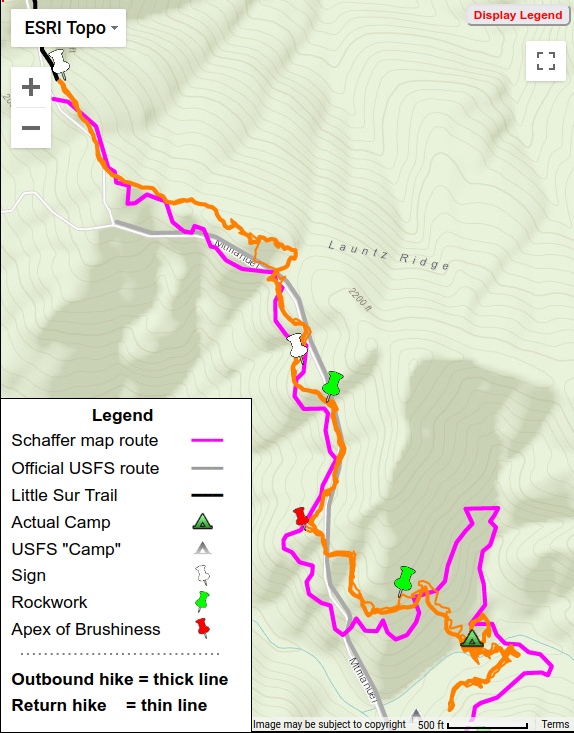
Extravagant flagging, an unhappy couple, Launtz Creek Camp is “found” but have to shortcut trail (with Paul Danielson)
Hike 2 = Orange
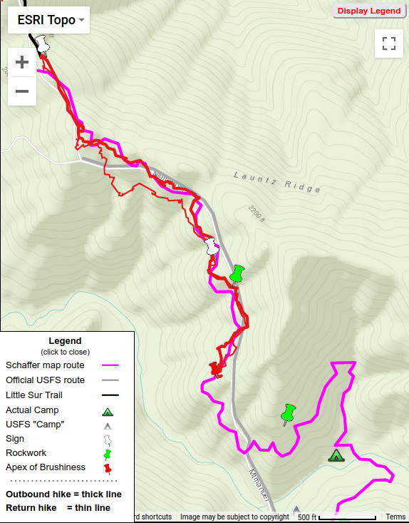
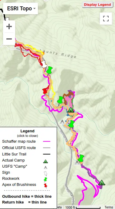
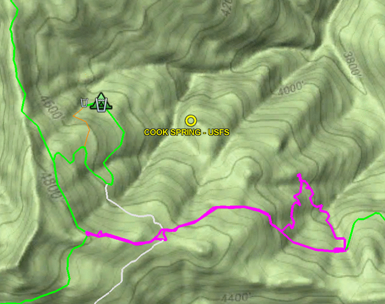
Over a year after our first hike, in February of 2012 Paul Danielson and I decided to re-visit the “lost” Mount Manuel Trail – to go beyond the ‘Apex of Brushiness’ which had stopped our last hike and hopefully reach, and so “find”, Launtz Creek Camp. This turned out to be the most interesting hike of my 11 hikes “finding” the Mount Manuel trail.
Little tread, much brush, give up at “Apex of Brushiness”
Find sign and rockwork, Paul follows deer track
(with Paul Danielson)
Hike 1 = Red
February 2011 found myself and Paul Danielson, who had introduced me to the wonders of hiking old trails in the Ventana Wilderness, at Pico Blanco Boy Scout Camp. We’d obtained permission and gate access, but were warned the dirt road was very rough as not worked on since summer. Indeed it was – I needed the 4WD of my Xterra, newly bought for just such places. Being my first time there, the camp’s setting under tall stately redwood trees with nearby creek was very impressive and peaceful.
Of the “lost” trails I GPS’d, the north end of the Mount Manuel Trail took more effort than any other. And in the end, was the one trail not completely mapped when foot problems prevented further work. In several sections the route went over steep slopes from which all tread had eroded and no trail clues could be found. In all, I made 11 hikes there between 2011 and 2016 looking for traces and clues (while aging from 65 to 70).
Wilderness boundary facts vs. un-facts (after being called “criminal”)
Everyone knows the internet is full of mis-information. And that mis-information is often passed on via social media. Having a gap in one’s knowledge, “simple ignorance”, becomes “damn ignorance” when that gap is filled with incorrect assumptions, or even made-up “facts”, and posted to the web as factual without any attempt to question or verify, spreading still more mis-information.
In 2005 Wilderness Press (“WP”) produced the first sheet map available for the backcountry Big Sur trails – before that, hikers had to depend upon upon quadrangle maps with their many drawbacks. I first used that WP map when exploring the Ventana Wilderness and always liked its very clean and readable format, with trail lines clearly displayed atop contour lines.
My “Finding the Carrizo Trail” post glossed over the fact that the western end of the Carrizo Trail of that time (2009) differed significantly from the current (2017) route. In my “Maps can lie” post, describing my mapping of that end, I had followed the route described in VWA Trail Reports: leave the North Coast Ridge Trail at a flag marking a ridge. At the time I’d noted the initial section was rough and sketchy, tread only becoming evident after leaving the ridge. I was later enlightened by Paul Danielson as we were hiking along the North Coast Ridge Trail – shortly after the Gamboa Trail junction, 0.6 miles before the ridge, he pointed out a spot where the “historic” Carrizo Trail junction had been. That route had become overgrown and abandoned, so hikers were instead taking a shortcut along an old dozer cut along the ridge.
In July of 2010, trailworker par excellence Robert Parks took it upon himself to restore that overgrown “historic” section. Over six worktrips, he and some helpers (including Paul Danielson) hacked and sawed their way through that brush. Much of the tread was still intact, so following the route itself was not too difficult. In October the final section was completed and a celebration held.
The Carrizo Trail is a historic route, used in the 1800’s by homesteaders driving their cattle and hogs to market in Jolon. After the construction of coastal highway it fell out of use but was later re-created by Steve Chambers and other VWA trailworkers, to connect the coastal ridge to the San Antonio River. But where exactly does it go? And where is the USFS “Carrizo Spring Camp” which lies along it?
Round trip: 11 miles & 3500 ft elevation gain Hike date: October 6, 2017
Carrizo Trail: 2009=red 2017=green (click to view interactive map)
Hearing that a section of the Carrizo Trail below Carrizo Spring Camp has recently been re-routed (see map), I went out to see what the new section looks like and GPS the new route. I found the trail has been moved out of the paralleling gully, into a drier environment. It should be subject to less overgrowth and easier to maintain – a definite improvement.
While I was out there, I decided to reprise my first Carrizo Trail mapping hike. That 2009 hike was motivated by wanting to find exactly where the trail went, since I’d found different routings on different maps. This hike would be more leisurely, for there has been significant trailwork along the entire trail since them. Back then there was much crawling in brush tunnels and much searching to find the trail – this time I only had to search once and never had to crawl! So I had more opportunity to look around and appreciate the trail and this hike and it was much more enjoyable.
 Hike 2 = Orange