but have to shortcut trail
(with Paul Danielson)
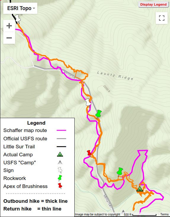 Hike 2 = Orange
 Hike 2 = Orange [Outbound=thick Return=thin]
Learning from our last trip, this time we got to Pico Blanco Boy Scout Camp very early, 7:30 AM. The hike up the Little Sur Trail to the Mount Manuel Trail trailhead was a bit easier than last time, now being familiar with the route, arriving there at 8:45.
Heading out on the Mount Manuel Trail, we were in for a surprise. Someone had been out on the trail, clearing some brush and also flagging their route. The flagging was astounding – the most profligate flagging I’ve ever seen! Yards of magenta tape were hanging from branches, wrapped around tree trunks, etc.
-30_Launtz2/IMG_6296.georef.JPG)
-30_Launtz2/IMG_6343.georef.JPG)
-30_Launtz2/IMG_6342.georef.jpg)
In wonder we followed this extravaganza along the north side of the ridge, to see where it would lead. The clearing allowed easier passage than on our last hike, but its route lay a bit north of what we had then taken.
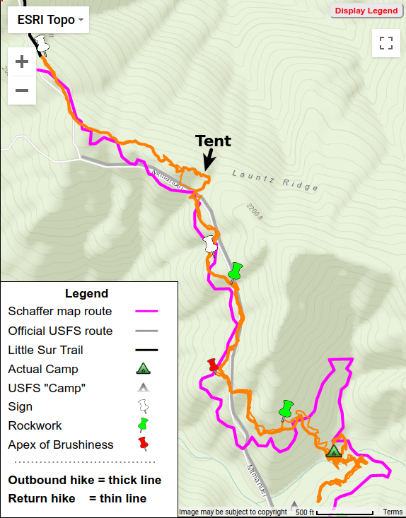
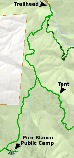
And then we found a tent with an unhappy couple.
-30_Launtz2/IMG_6297.georef.jpg)
We learned they had intended to camp at Pico Blanco Public Camp, which lies along the Little Sur Trail. Somehow they’d gotten sidetracked onto the Mount Manuel Trail, possibly allured by the flagging (which had not been on the Little Sur Trail). What astounded me was the guy had a GPS! But apparently did not know how to use it.
Nightfall found them up on the ridge, where they had to camp without water, having relied on finding water at the camp. They’d planned a multi-day outing, so I tried to show the guy on his GPS how to get to Pico Blanco Public Camp. We then left to continue our trek.
We continued a bit further, finding no more flagging beyond the tent site so that must have been the flagger’s destination – later made me wonder if the couple had been the flaggers, but then too late to ask. Bushwhacking to cross over the ridge, we regained our previous hike’s route on its south side and the brush lessened
-30_Launtz2/IMG_6334.georef.JPG)
After passing a “Boundary Tree” sign,
-30_Launtz2/IMG_6335.georef.jpg)
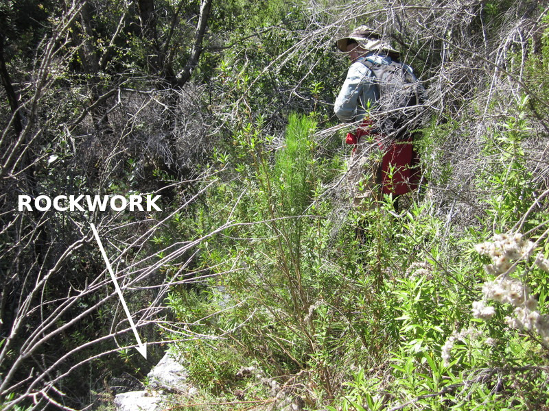
and rockwork, familiar from our last hike, the brushiness increased until finally we were stopped by the brush and downed branches wall at the “Apex of Brushiness”. That had defeated us on our last hike, but we attacked with saws and loppers and cleared a passage to squeeze through. After the “Apex” the route changed from southwest to southeast, so from a northerly to southerly exposure and the brushiness lessened – and tread became a bit more distinct
-30_Launtz2/IMG_6329.georef.JPG)
-30_Launtz2/IMG_6323.georef.JPG)
Later some new rockwork indicated we were definitely on the trail.
Reaching a point on the steep slope above the Launtz Creek Camp, according to Schaffer’s map, to save time we decided to simply bushwhack down the slope instead of trying to follow the trail’s long switchback, skipping its additional 0.4 miles of trail (a good decision, since later hikes found absolutely no tread or trail indicators over much of that section). After hunting around a bit, at noon we arrived at restful Launtz Creek Camp set amidst the redwoods, with its USFS grate
-30_Launtz2/IMG_6310.georef.JPG)
and sign on the ground,
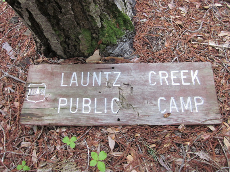
and water available from Launtz Creek.
-30_Launtz2/IMG_6318.georef.JPG)
Launtz Camp had been “found”, 1/8 mile northeast of the USFS location. And the USFS trail line differed considerably from the old tread we had followed (see map).
While eating lunch, we congratulated ourselves on this time being successful. Paul decided to commemorate the event by taking a “Ventana Trails Forever” campaign card of his, adding the date and my name and placing it under the hinged plate atop the grate (a later poignant find).
But Paul’s 73 years was telling on him, he felt too tired to go further. Being a youngster of 66, I went on to investigate the old homestead site along the creek, then decided to see if I could follow the continuing trail. A bit above the creek I found definite tread and followed it southwesterly. But it became more brushy as it neared the apex where it would change direction – so being “a bit tired” myself went back to Paul at Launtz Creek Camp.
We returned the way we had come. I wondered what happened to the couple, since the woman had made it clear she was not a happy camper – I suspected they might just decide to head back to civilization instead of trying for the Public Camp.
Arriving back at my Xterra just at sunset, we left with a feeling of accomplishment and satisfaction.
After the hike, I noted that beyond the “Apex of Brushiness” our track was off-set from Schaffer’s map route by 150-350 feet, indicating the topography of the map Jeff used differed significantly from the actual terrain. So while his mapping was helpful, it could not be definitive. The truer latitude/longitude route was stored within in my two GPSes – and quite different from the official USFS trail route.
Total hike time was 11.2 hours. Our hiking speeds give a sense for the trail roughness and hike difficulty: 1.4 mph (steep uphill) and 1.9 mph on our outbound and return legs along the Little Sur Trail but slowing to 0.36 mph and 0.26 mph respectively on the Mount Manuel Trail to the camp – the slowness of the last reflected our doing some sawing and lopping on the return trip.
Wow – that’s a pretty brushy trail
The trail is now five foot (at its smallest) wide now from the junction to the camp. We cleared the Shaffer route.
Nice story about later finding Paul’s card. Sounds like quite a guy.
John is referring to the link under “(a later poignant find)”, which describes my many years later unexpectedly finding the card Paul had placed that day in the grate – after Paul had died and I was out there alone. I’d completely forgotten about that, brought back a flood of memories.
Yes, Paul was quite a guy – loved by all who knew him, from fellow hikers to his students at All Saints School. Ordained into the Episcopal priesthood, he truly lived his faith with his caring for others. And his roots in the Ventana lay deep, having hiked all its trails, helped its creation as a wilderness area, served on board of Big Sur Land Trust, etc. I was fortunate to have learned much from him during our travels to and from trailheads on our over 60 hikes together, and much of that knowledge lives on inside Big Sur Trailmap.
He is still missed by many. In Memoriam
Looking a lot better! We were back there in November and it was not flagged at all and badly overgrown. We gave up searching for Vado when we ran out of light. I’ve been skunked 3 times now, hah.
I added some flagging on Little Sur trail and did some work on some downed trees, the ticks were bad though!
Hope you are well Jack!
Geoff
Good to hear from you again, glad you are continuing to get to the less-explored parts of the wilderness. Unsure how far you got when heading for Vado, but FYI is mostly overgrown on the other side of Launtz Creek and essentially a bushwack after leaving that drainage to follow the South Fork Little Sur River. Guess I should add blog posts on what I found there on my later hikes …
Jack