
Rattlesnake Creek Trail (2E11) and Rattlesnake Camp
in the Ventana Wilderness
A Brief History
Jack Glendening
Because of its historical significance, being one of the oldest in the Ventana though now much forgotten, I've developed an attachment for Rattlesnake Creek Trail and to Rattlesnake Camp, the peaceful, secluded, and seldom visited camp which lies along it. This webpage pulls together bits of information I've gathered.
THE TRAIL
Early history
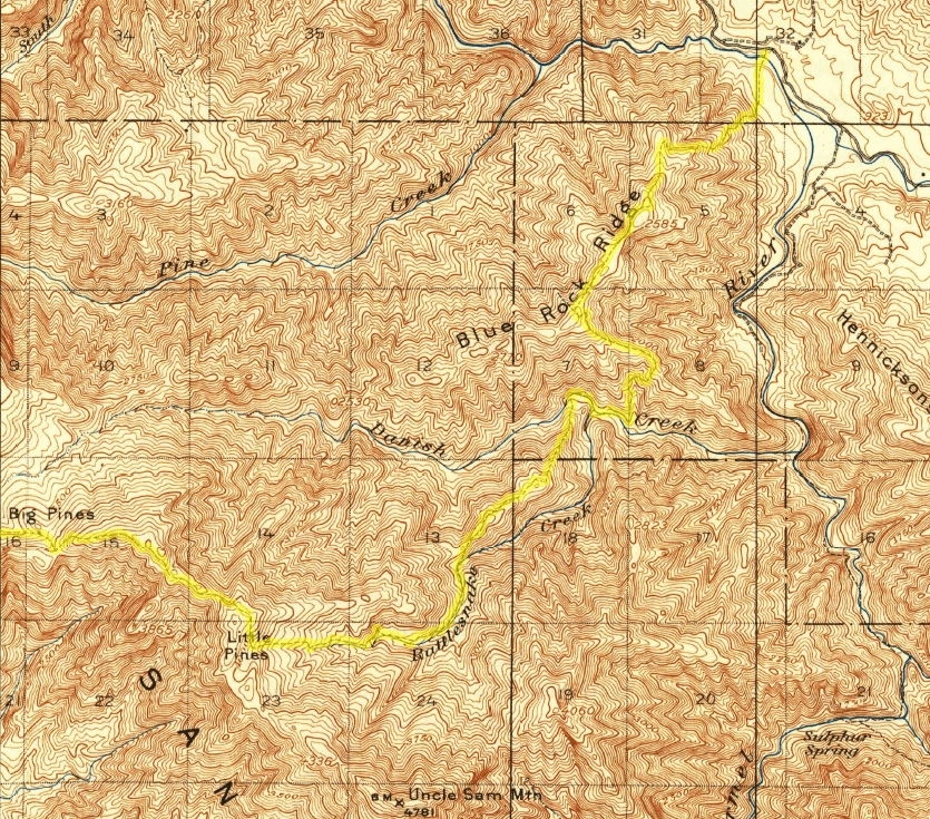
Rattlesnake Creek Trail has a long history, being one of the Ventana's earliest trails. The 1924 Santa Barbara National Forest map
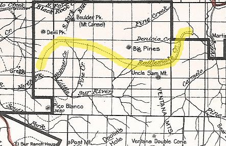
shows it connecting with Devils Peak and the Little Sur drainage - so before the existence of the current Big Pines Trail, Ventana Double Cone Trail, Puerto Suelo Trail, Danish Creek Trail, and even the Carmel River Trail. The 1921 USGS Jamesburg Quadrangle map (based on 1917 surveys) shows more detail. Sections of the original Rattlesnake Creek Trail have now been reconfigured and renamed to become sections of the Big Pines, Danish Creek, and Skinner Ridge Trails - the official USFS Rattlesnake Creek Trail currently terminates at trailheads on the Big Pines and Ventana Double Cone Trails. (Attentive map readers will note how 'Danica Creek' as been altered into the current 'Danish Creek' identification, likely explaining its atypical pronunciation "Da-NEE-sh".)
(for larger area)
1930-1960: VDC Trail development
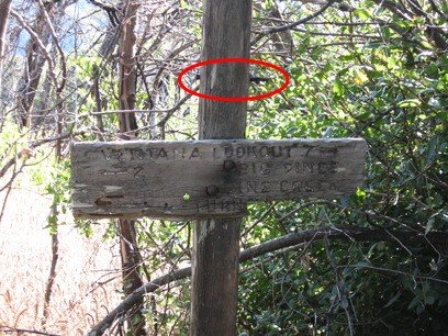
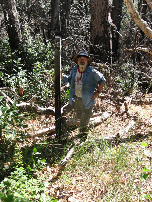
Rattlesnake Creek Trail was used to support initial construction (1935-36) and resupply of the VDC lookout tower and trail via mule train. (Later, for unknown reasons, the resupply route was changed to Bottchers Gap.). Sometime, apparently after 1956, its uppermost end was rerouted, probably a "bypass" to make the VDC ascent more direct - the later route heads SW from Little Pines Spring (instead of NW) to intersect the current VDC Trail. Until 2016, the historic 1921 route was still marked by a signpost along the VDC Trail, its trail sign having been removed (presumably after the "bypass" re-routing) to leave just holes and a bolt. But though escaping many past fires, the sign and its post were finally destroyed by the Soberanes fire in 2016.
(note bolt for missing 90° signboard)
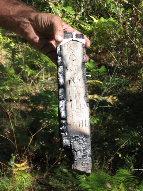
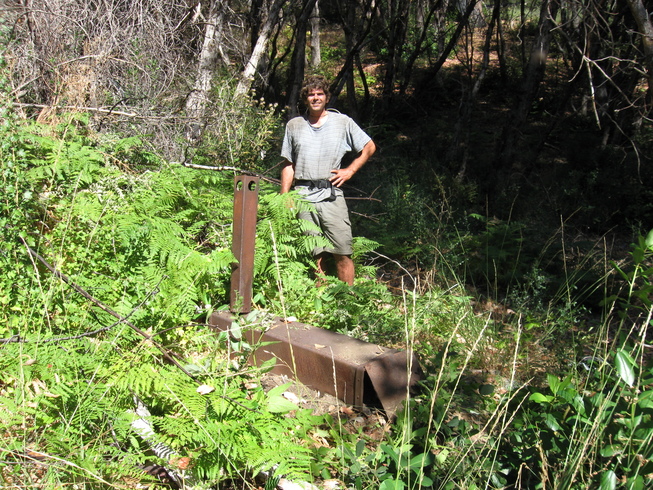
Joining the previously burnt sign at the upper end of the re-routed trail.
The on-line Big Sur Trailmap depicts both the 1921 and later bypass routes.
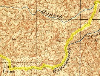
1960's: trail restoration
At some unknown date the trail fell into disuse. It was reopened by H.J. McCracken circa 1965, who placed tin markers on trees to guide hikers along the trail, essentially following the 1921 quadrangle map route.
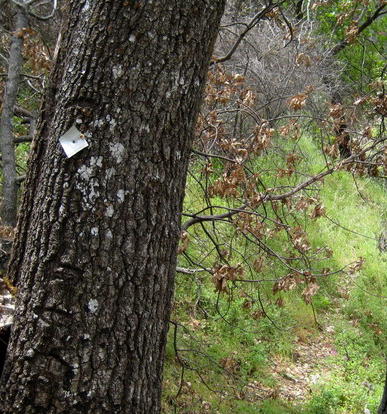
These markers can be found from Danish Creek up to Little Pines Camp, though sparser at the higher elevations. (Above there, my guess is that he followed the 1921 route, not the later bypass route - but never found any markers above Little Pines Camp along either route.)
1990-2010: sporadic maintenance
The trail has been maintained sporadically since its restoration. In the 1990's, Bob Eaton's Ventana Mounted Assistance Group and some Cachagua locals helped maintain the trail. It later became impassable but was restored in the 2000's by Rami Shihadeh, Jan Doelman, and Stephenson School hikers - and likely unknown others. But by 2010 it was again overgrown above Rattlesnake Camp.
2010: my introduction
My personal acquaintance with Rattlesnake Creek Trail and Rattlesnake Camp came in 2010, after losing the trail in brush above the camp on a dayhike. I did an overnight backpack to explore further and flag the trail markers I could find above the camp, then asked Jan Doelman to show me the upper, mostly unmarked, trail. He, Rami, and Paul Danielson helped clear brush to where the trail leaves the creek and the following day Jan led me up the remaining, less brushy, section to the VDC Trail. (In a culmination, three weeks later I backpacked up Rattlesnake Creek Trail, staying overnight at Little Pines Camp, to make my first VDC summit on Oct 26, 2010.) I believe this was the last time that any clearing was done above Rattlesnake Camp.
2010+: above Rattlesnake Camp
I did not do any later work on the section above the camp (nor did anyone else, to my knowledge) so that became impassable, as attested by my 2013 experience trying to go down from the VDC Trail to Little Pines Spring. So I had to make that a "lost" trail location on my Big Sur Trailmap .
2010+: Rattlesnake Camp
I made periodic trips from Danish Creek up to Rattlesnake Camp, the last in November 2015, doing some lopping and sawing and flagging - so that section remained difficult but doable for the determined hiker (though a GPS with accurate trail data was very helpful).
2017: Post Soberanes Wildfire
The 2016 Soberanes Wildfire went through the Rattlesnake Creek Trail, with a spotty burn down to Danish Creek. Rattlesnake Camp itself did survive the fire but the following winter saw multiple storms with heavy rains, leading to downfall and brush growth that heavily impacted the historic McCracken trail route along the ridge, rendering it almost impassable. Better to bushwhack on the more open southern side of the ridge.
The trail above Rattlesnake Camp has been completely lost, and sadly the historic signpost along the Ventana Double Cone Trail pictured above, after surviving many wildfires since its erection, is now gone.
Around this time the metal ammo box containing the register I'd placed at Rattlesnake Camp was apparently torn apart by a bear, the register lost and not replaced. Photographs of its entries from 2010 to 2015 are at at Rattlesnake Camp Register
2022+: Restoration with ridgeline re-route
In 2022 Alan Harder took it upon himself to make multiple trips working on the Rattlesnake Trail, brushing and flagging. Due to the heavy growth on the north side of the ridge, he opted to switch to the south side of the ridge for part of that route, and eventually restored access to Rattlesnake Camp.
Since that time some intrepid adventurers have made it to the camp, albeit with some difficulty - you can read their accounts on the trail's Trail Report forum.
THE CAMPS
Rattlesnake Camp
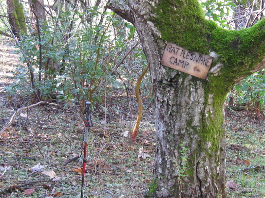
A metal sign near the trailhead at Danish Creek (36.37659,-121.68831) points adventuresome hikers to this historic camp.
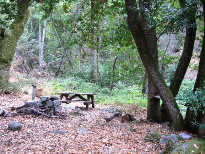
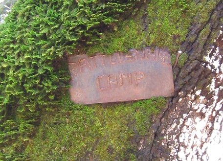
Rattlesnake Camp has surviveda numerous wildfires, the most recent being the 2016 Soberanes Wildfire which only singed the camp. As of my last visit in 2017, Rattlesnake Camp remains in good shape, no trees having fallen on it,
still with its sign
(2010)a sturdy picnic table (though showing some wear) with USFS grate
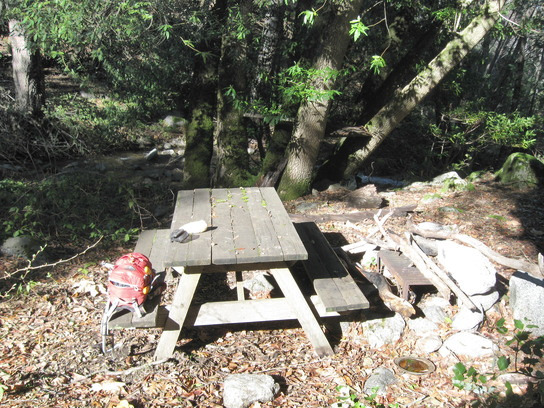
and an icemaker stove with chimney (apparently a later replacement, since no rust) .
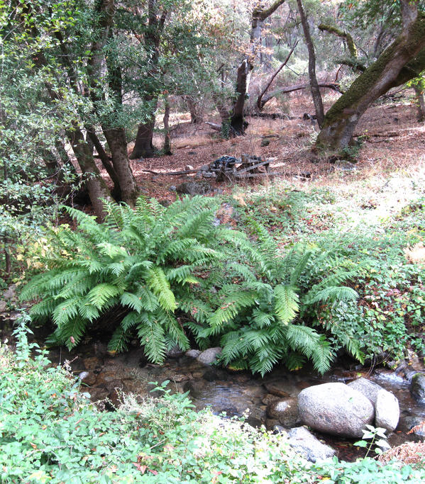
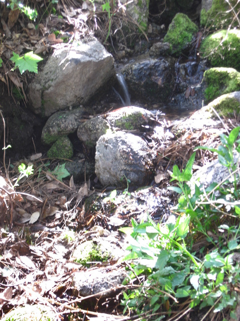
Rattlesnake Creek happily burbles alongside (I've always found water, even in drought when lower Danish Creek was bone dry).
In 2010 I placed a camp register there so the few hikers who reached it could record their tale and read about others who have passed that way - but around 2025 a bear later found and trashed its metal ammo box (I found only its top), and it was never replaced.
Historic Little Pines Camp
"Little Pines Camp" used to be lie along the trail about 150 feet below Little Pines Spring - a basin up in a tree marks that location, near a tree blaze (36.35502,-121.72225).
(note basin in tree)
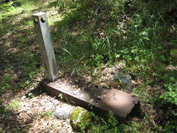
Unfortunately the 1977 Marble Cone Fire led to erosion which filled its flat area - so sign and icemaker stove were relocated - see below.
Later Little Pines Camp
After 1977 Marble Cone Fire erosion, the original camp sign
and its icemaker stove
were relocated a flat area 1/8 mile below Little Pines Spring, 50 ft south of the trail (36.35550,-121.72075). A huge pine later fell, largely covering the area, the sign burned, and the site was no longer used.
Little Pines "Use" Camp
When the "bypass" route was passable, hikers taking the VDC Trail to VDC summit would often camp at the trail's upper end, going down 1/4 mile to get water at Little Pines Spring. Many maps show a "Little Pines Camp" at that location, but to my understanding the true camp, with sign and stove, was at the "basin in tree" location described above so this was really a "use camp" - but with the loss of the "historic" Little Pines Camp, this can be considered the "new" Little Pines Camp. Unfortunately, the route to the spring is overgrown so this use camp is now "dry" and seldom used.
EXPERIENCING
If you decide to visit Rattlesnake Camp, now remote and lonely and ever more peaceful, you will be traveling a route long in history - now forgotten by many but fondly remembered by others
 .
Depending upon volunteer maintenance, the route can be brushy - check out the Trail Report
to learn of current conditions - and ideally bring along loppers and/or saw to do some clearing along the way.
If you do make it, please
leave a report on the on-line camp register
and/or
post to the trail's Trail Report
so others can read about your adventure
- people like me will love hearing about it and it will encourage others to also visit!
.
Depending upon volunteer maintenance, the route can be brushy - check out the Trail Report
to learn of current conditions - and ideally bring along loppers and/or saw to do some clearing along the way.
If you do make it, please
leave a report on the on-line camp register
and/or
post to the trail's Trail Report
so others can read about your adventure
- people like me will love hearing about it and it will encourage others to also visit!
Coda
Sierra Club Trail Guide to Los Padres National Forest (Fifth edition, 1989)
"By some miracle, Rattlesnake Camp and its immediate environs escaped the fire devastation of 1977. So it is one of the few areas that still give the sense of virgin forest, with handsome mature trees. H.J. McCracken, the grand old hiker who died later in Anderson Canyon, first reopened the trail to Rattlesnake Camp over 20 years ago and nailed the markers to the trees. The many friends who loved and admired him can think of peaceful, forgotten Rattlesnake Camp as his permanent memorial."
CURRENT MAPS
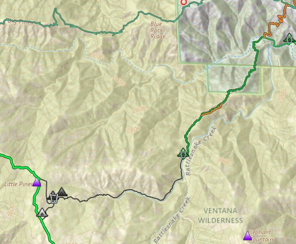
note: Rattlesnake Camp is mis-located on many maps, sited along a ridgeline
- but the camp actually lies 0.8 mile beyond, beside Rattlesnake Creek.)
Full-screen Interactive Map with Rattlesnake Camp Route
3D Interactive Map with Rattlesnake Camp Route
One-page-printable PDF Route Map
If you have something to contribute or find an error, you can send an email to Jack Glendening at:
 or post to the Trailmap Forum (later preferred, as others
may have same question/problem).
Additions or corrections will be credited.
or post to the Trailmap Forum (later preferred, as others
may have same question/problem).
Additions or corrections will be credited.

Copyright: This page and photos and data are copyrighted
by John W. (Jack) Glendening.
Public use permitted
under the CC‑BY‑NC‑4 license.