Route Advice
Last Chance Falls is seasonal, slowing to trickle after the rainy season.
Is most impressive after rainfall, but after heavy rains Santa Lucia Creek crossings can become difficult or impossible -
so after rains suggest starting loop in clockwise direction, assessing flow of Santa Lucia Creek at the first crossing
(near Lucia Adobe, just beyond south end of Camp Cawatre Trail),
then if too strong skipping the Santa Lucia Creek crossings by contining to ArroyoSeco-Indians Fireroad and from there doing an out-and-back along the route.
(FYI the Santa Lucia Creek crossings upstream of the near-Adobe crossing have significantly less flow, being upstream of several confluences.)
The goal of this strenuous hike for adventurous and experienced hikers
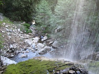
is Last Chance Falls, the most spectacular waterfall in the Ventana
Wilderness with Santa Lucia Creek free-falling 120 feet into a pool
below. But we will also hike through narrow Santa Lucia Creek gorge to view
its waterfalls as well as the much wider Arroyo Seco gorge with its rapids and
waterfalls. And we will ascend to enjoy grand views at the
ridgelines above both gorges.
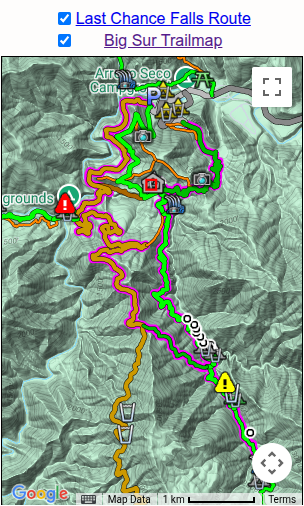
Our route is overlaid in magenta on the adjacent display from the
on-line Big Sur
Trailmap.
The hike begins near southern Abbott Lake, first following its
shoreline and then climbing south to the ridge, where a wonderful
panorama includes a look ahead into the gorge of Santa Lucia Creek
and its waterfalls. Descending to the still-standing
Lucia Adobe,
which
was once a Forest Service Ranger post, on a site once occupied by the
former Girl Scout Camp Cawatre, we ford Santa Lucia Creek at a
concrete automobile crossing.
[Should the creek flow be too
high/strong to allow a crossing, we will instead hike to Last Chance
Falls via ArroyoSeco-Indians Fireroad.] We climb and go a bit off-trail
so that we can simultaneously view
Mutt and Jeff Falls,
two dissimilar
falls which meet just below us. Continuing south along the Santa
Lucia Creek gorge will provide some wonderful views of rugged
mountains and canyons - and more waterfalls. We descend to
make 8 creek crossings within a half-mile before exiting Santa Lucia
Creek gorge. We ascend to cross a small saddle, then again
descend to the south fork of Santa Lucia Creek, crossing it just beyond Last Chance Camp
and climbing again to reach a viewpoint of Last Chance Falls, to see
the creek with which we have now become intimately familiar plunge
downward on its fated journey over a massive cliff wall. Returning to Last Chance Camp,
instead of going back along our inbound route, we ascend up to the
old Indians road for magnificent views of close and distant
mountains, and of the Arroyo Seco canyon and river below us. We
follow the old road as it descends and winds its way north, finishing
along the Arroyo Seco gorge, where we will see rapids and at least one
waterfall.
The hike is very strenuous, with a total distance of 15 miles and
cumulative 3700 feet of ascent.
[Should the alternate approach
via Indians Road be necessary, the hike becomes 17.5 miles
with 4400 ft of ascent, though over a better maintained route.]
While it is entirely on-trail, experienced Ventana hikers understand
that a "Ventana Wilderness trail" is sometimes more "wilderness" than
"trail". The hike may involve contact with and/or pushing
through brush and poison oak and occasional poor footing. There will
be multiple river crossings, but none above thigh-high. The hike
will take a full day, starting at the trailhead near sunrise.
(The drive to the trailhead requires 1.3 hours from Salinas.) One
reason for the early start is to allow time for stopping at the many
viewpoints.
I expect to complete the hike during daylight, but just barely, so
bring along a headlamp in case we get delayed and have to finish after
dark. Poles are very useful, even required, when crossing Santa
Lucia Creek. Because of the numerous crossings, some may wish to
bring some kind of water shoes. Personally, I wear my regular
boots through the crossings but carry multiple sets of dry socks,
changing to dry socks after the first crossing and after the final
crossing in the gorge - generally the upper crossing near Last Chance
Camp can be done by rock hopping. Note that we do not have time
to be stopping for footwear changes at each of the 8 crossings in
Santa Lucia gorge - you should expect to wear whatever footwear you
decide upon for that entire section. And last but certainly not
least, I suggest bringing a camera since views along the route are
wonderful!

May 2018 update
May 2018: I finally did what I'd long thought of doing, going to the base of the falls.
It's relatively easy and especially recommended for lower flows when the falls is less visually impressive from afar.
There aren't many waterfalls you can go "behind"!
I've added an orange "usetrail" to the map indicating a route often used.