Finding the Mount Manuel Trail – Mapping technique
Of the “lost” trails I GPS’d, the north end of the Mount Manuel Trail took more effort than any other. And in the end, was the one trail not completely mapped when foot problems prevented further work. In several sections the route went over steep slopes from which all tread had eroded and no trail clues could be found. In all, I made 11 hikes there between 2011 and 2016 looking for traces and clues (while aging from 65 to 70).
[Larger images shown on larger screens]
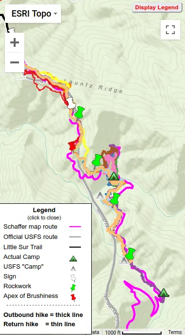
In later posts I’ll describe those hikes as an example of how a “lost” trail becomes “found”, but in this post will describe my mapping technique. FYI below is an animated interactive map of all 11 hikes, plus Schaffer and USFS trail routes.
Ideally tread exists sufficient to follow and GPS a trail. But when a trail is overgrown, having had no maintenance and little to no usage, tread disappears. My trail mapping technique has been to
Use dedicated GPS: When I started, a handheld Garmin GPS (GPSMAP 60) had just come onto the market – without that availability I could not have attempted this mapping project. Over the years, newer Garmin units were used, always models with the more capable “quad” antenna and with buttons for input with gloves on. A phone with its questionable ruggedness, less capable antenna, and poor in-daylight-visibility touchscreen was not going to cut it!
[The need to mark frequent trail “clues” necessitated outside access to one GPS – due to the brush encountered, I had to buy a special clip to hold the GPS securely. And had to eventually replace my first GPS due to brush trashing its buttons.]
Use multiple GPSes: I carried two GPSes – the second as backup and also, since all individual tracks have error, to allow track averaging. And if the two GPS tracks differed significantly – in poor reception conditions a track can suddenly shift, the unshifted one would indicate the “correct” track.
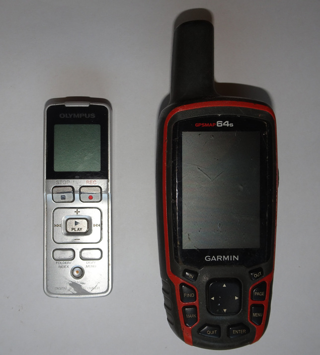
Save clues on GPS and recorder: in the absence of tread, one must look for other clues. Examples of “definite” trail indicators are rockwork and sawed trunks. Also useful are old flags and cut branches. Sometime “tread” seems to be found but can be questionable – deer and other animal paths abound. I carried an Olympus voice recorder and if not on obvious tread, upon finding a clue would put a marker into my GPS and record the type and quality of that evidence – or if the apparent tread became questionable would mark+note that. After the hike, I’d save the tracks and waypoints and transcribe recorder notes – when the route of the trail was questionable I could piece together the “good” points. Most trails were traversed at least twice, often as in-and-out dayhikes. [The use of separate gps and recorder – both with buttons – was important in allowing frequent marking without slowing me down, since button muscle-memory allowed me to mark+record without having to look or stop moving – two presses on a gps button (automatically increasing the waypoint number), then four on recorder buttons (on-record-stop-off). I tried a touch-screen gps once but quickly abandoned that due to the time required, besides its problem with brush touching/scratching the touch-screen.]
Have a preliminary guess: when available, I put a georeferenced trail route from a map in Jeffrey Schaffer’s “Hiking the Big Sur Country” (1988) into my GPSes. While I also had track and camp info from the USFS that was often found to be misleading and unhelpful, as was true for the Mt. Manuel Trail). Unfortunately even Schaffer’s routes had enough error (see box below) that they were often not useful for re-finding a trail when tread was lost. Another example – once when I could not follow the faint tread after it went into a large area covered with blowdown trees, I luckily found an old satellite image showing a switchback emerging from that area – so that point was put into the GPS as a “go-to” for my next attempt.
Mapping tools (original voice recorder and later GPS)
Jeff “Mad Dog” Schaffer, whom I met twice in person so able to talk for several hours, worked before GPS was available, becoming familiar with mapping techniques during his geological training. He used compass and step-counting together with topo maps to produce high-quality trail maps. He emphasized to me that the accuracy of his trail mapping was limited by the accuracy of the topo maps he used – if actual terrain differs from that, a lat/lon obtained from a georeferenced map will not be accurate, and back then, terrain data was not of today’s accuracy. So the changes of direction, twists and turns, of his lines were more significant than their exact location. (BTW the same is true for my mapping, hence I make Big Sur Trailmap trails sequences of short straight lines rather than a smoothed line.)
Jeff’s initial fame came from mapping the Pacific Coast Trail, authoring several trailblazing guidebooks published by Wilderness Press in the early 1970s. In the late 1980’s he mapped the Ventana Wilderness (and Big Sur State Parks, but not the Silver Peak Wilderness) and published them in Wilderness Press’s “Hiking the Big Sur County” – the first reliable maps of the Ventana Wilderness trail system (though with some omissions, the Black Cone Trail for example). How this came about (he did not initially want to do the mapping) and his resulting mixed feelings (for one, he disliked the photo used for the cover) makes an interesting story – if we should meet, you can ask.
2 comments on “Finding the Mount Manuel Trail – Mapping technique”
“Lost” 3 GPSes in early hikes when brush pulled out of Garmin clip – but since often making waypoints with bad trail in brush, for 2 of those discovered loss soon after and was able to backtrack and “find” it. But one was lost irretrieveably.
So motivated to find solution, found non-Garmin clip which required GPS to be a right-angle for clip to disengage. Afterward only “lost” one, when leg got parallel to ground going over downed tree, but that discovered soon after and backtracked to find, so never actually lost one with new clip.

So did you ever lose a GPS ?
“Lost” 3 GPSes in early hikes when brush pulled out of Garmin clip – but since often making waypoints with bad trail in brush, for 2 of those discovered loss soon after and was able to backtrack and “find” it. But one was lost irretrieveably.
So motivated to find solution, found non-Garmin clip which required GPS to be a right-angle for clip to disengage. Afterward only “lost” one, when leg got parallel to ground going over downed tree, but that discovered soon after and backtracked to find, so never actually lost one with new clip.